Ministry of Natural Resources: Typhoon Sura’s approaching wave red warning and storm surge orange warning.
CCTV News:The super typhoon Sura has moved into the northeastern part of the South China Sea, and gradually approached the eastern coast of Guangdong. It is expected that there will be huge waves to wild waves in the coastal waters of eastern Guangdong, and there will be large storms and water increase in the coastal areas of Xiamen, Zhangzhou, Chaozhou and Shantou in Fujian Province. The National Ocean Forecasting Station today (31 ST) morning.willseaWave warning level is upgraded to red.,Upgrade the storm surge warning level to orange. According to the Emergency Plan for Marine Disasters,The Ministry of Natural Resources adjusted the emergency response level of marine disasters to level II this morning..
The center of the No.9 typhoon "Sura" (super typhoon level) this year is located on the sea about 300 kilometers southeast of Huilai, Guangdong at 8 o’clock today. According to the forecast of the Central Meteorological Observatory, "Sura" will gradually approach the coastal area of eastern Guangdong, and its intensity will slowly weaken. It will land in the coastal area of Huilai, Guangdong from the afternoon of September 1 to the night, and it may also move to the south-west direction in the coastal area of eastern Guangdong.
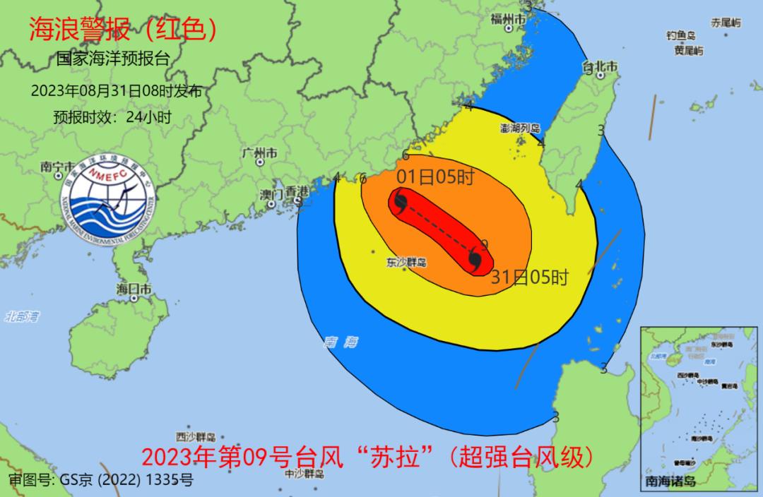
Wave aspect
It is estimated that from noon on August 31st to noon on September 1st, there will be 8-12m wild waves in the northeast of the South China Sea and 4-6m huge waves in the south of the Taiwan Province Strait.The warning level of offshore waves is orange.; There will be huge waves of 4 to 6 meters to wild waves in the coastal waters of eastern Guangdong.The warning level of waves in the coastal waters is red.There will be huge waves of 3 to 4.4 meters in the coastal waters of southern Fujian.The warning level of waves in the coastal waters is yellow.There will be a medium wave to a big wave of 2 to 3 meters in the coastal waters of northern Fujian.The warning level of waves in the coastal waters is blue.. Please pay attention to the safety of vessels operating in the above-mentioned sea areas, and all relevant coastal units shall take measures to prevent and avoid waves in advance.
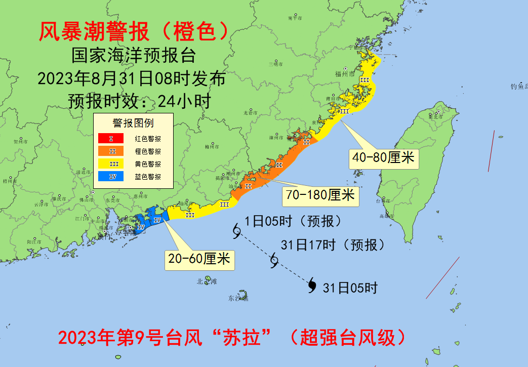
Storm surge
It is estimated that from the morning of August 31st to the noon of September 1st, there will be 40-80cm storm surge along the coast from Fuzhou, Fujian to Quanzhou, 70-180cm storm surge along the coast from Xiamen, Fujian to Shanwei, Guangdong, and 20-60cm storm surge along the coasts of Huizhou and Shenzhen, Guangdong.The warning level of storm surge in Xiamen, Zhangzhou, Chaozhou and Shantou of Fujian Province is orange.,The warning level of storm surge in Fuzhou, Putian, Quanzhou, Jieyang and Shanwei in Fujian Province is yellow..
The National Ocean Forecasting Station reminds ships operating in typhoon-affected waters to pay attention to safety; Relevant units along the coast take measures to prevent and avoid waves in advance, as well as emergency rescue work to prevent storm surges; Organize all kinds of ships to return to Hong Kong to take shelter from the wind, strengthen coastal fishery and aquaculture facilities and fishing port facilities, and evacuate relevant offshore operators in time; Close beaches and recreational facilities in coastal dangerous areas, and prohibit people from playing at the seaside; Strengthen the inspection of coastal seawalls, sluices and other facilities, reinforce seawalls in weak areas and dangerous areas in time, and if necessary, evacuate relevant personnel and transfer them to safe areas.